Data-Driven Flood Mitigation in Milwaukee
The Health Impacts of Flooding
In addition to the physical damage to the built environment caused by flooding, more frequent and intense flooding also has a direct impact on our health. In urban areas with aging stormwater infrastructure, heavy rain can cause sewage overflows and waterborne diseases to spread. Standing water following storms can become hosts to mosquitos and other disease-carrying insects. Flooding in homes and basements can lead to mildew and mold, which worsens asthma, exacerbates other respiratory challenges, and causes illness. Extreme flood events can also lead to traumatic stress and amplify existing mental health challenges.
The impacts of flooding are of particular concern in the Midwest, where the amount of rainfall during intense precipitation events has increased by 42% since 1956. In Milwaukee, WI, the City Government and the Milwaukee Metropolitan Sewerage District have begun efforts to renovate the old sewage system and install green infrastructure to help reduce the impact of flooding. It’s important that, as these improvements are made, priority is given to neighborhoods where residents will be most negatively impacted by flooding.
Data drives solutions
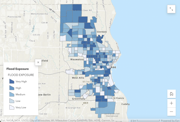
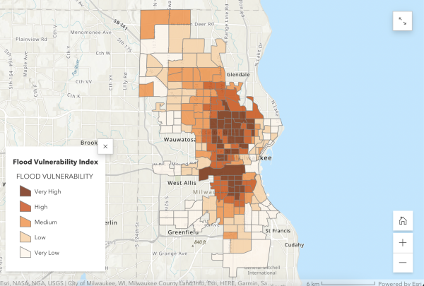
To help ensure that infrastructure is being prioritized where it’s needed most, Groundwork Milwaukee, in partnership with Wisconsin Health Professionals for Climate Action, The New School, Data You Can Use, and the Medical College of Wisconsin, carried out a Flood Health Vulnerability Assessment (FHVA) to identify neighborhoods in Milwaukee that are disproportionately at risk of flood damage. In this FHVA, Groundwork Milwaukee considered both flood exposure (the likelihood of an area flooding) and flood vulnerability (the degree to which residents will be impacted by flooding) at the Census tract level. They determined the flood vulnerability of each neighborhood by looking at a combination of health, socioeconomic, and housing indicators, which taken together are indicative of a community’s capacity to survive, adapt, and restore itself after a flood event.
The FHVA found that approximately 39% of Milwaukee’s population lives in a neighborhood with high flood exposure, high flood vulnerability, or both. And, the study found that not all residents are equally susceptible to the physical and health risks of flooding. Compared to the rest of the city, Black residents are more likely to live in high-flood-exposure and high-flood-vulnerability Milwaukee neighborhoods, due to economic factors, like poverty and unemployment, and difficulty accessing healthcare. Groundwork Milwaukee and its partners can use these results to prioritize flood management intervention efforts in neighborhoods that are most at risk.
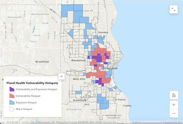
What Does it Mean to Live in a Flood Vulnerability Hotspot?
The Metcalfe Park neighborhood in Milwaukee is one of these priority areas, with a high exposure and high vulnerability to flooding.
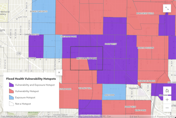
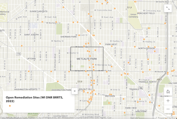
Inland pluvial flooding – flooding that occurs with high-volume precipitation events, like flash floods – is of particular concern in Metcalfe Park. The high density of brownfield sites and blighted land in the neighborhood increase the possibility of exposing residents to toxic pollutants, intensifying flood-related health concerns.
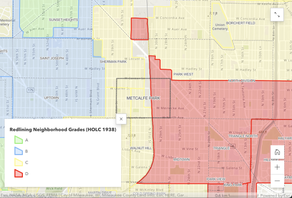
Metcalfe Park is surrounded by an industrial zone and is divided by the 30th Street Corridor railway. Its proximity to this infrastructure has created lasting social, health, and economic challenges in the neighborhood. Historic redlining policies in the 1930s determined that both the east and west halves of the neighborhood on either side of the railway were not suitable for mortgage loans, facilitating racial and economic segregation that remains to this day, with ~98% of Metcalfe Park residents identifying as BIPOC.
These policy decisions have affected the community’s ability to build wealth, access healthcare, and acquire resources for climate adaptation. When Metcalfe Park floods, many residents struggle to pay to repair property damage, and as persistent flooding increases the likelihood of adverse health effects, the lack of healthcare access becomes even more challenging.
Putting the data to use
Having data from the FHVA about Metcalfe Park’s acute vulnerability to flooding will allow residents and local groups to advocate for equitable investments in flood mitigation infrastructure for the neighborhood. Groundwork Milwaukee will be leveraging the results of the FHVA and the accompanying maps as a core part of their Climate Safe Neighborhoods partnership, in which they are using data about historic discriminatory housing policies to illuminate residents’ current climate experiences and engaging community members to organize to change the way climate adaptation resources are distributed.
By visually highlighting the overlap between flood exposure and vulnerability, the FHVA puts a powerful tool in the hands of the Metcalfe Park community to advocate for flood resilience and investments in flood mitigation infrastructure from policymakers.
To learn more about the Flood Health Vulnerability Assessment, visit Groundwork Milwaukee’s website.